 Drone Ground Control Point (GCP) – UAV Aerial Target for Mapping & Surveying (6 Pack) | Iron Cross Center Passthrough (Black/White Markers)")
Sky High Bull’s-Eye (24”x24”) Drone Ground Control Point (GCP) – UAV Aerial Target for Mapping & Surveying (6 Pack) | Iron Cross Center Passthrough (Black/White Markers)
$59.99


Price: $59.99
(as of May 20, 2026 19:21:09 UTC – Details)

Product description


Drone ground Control Points
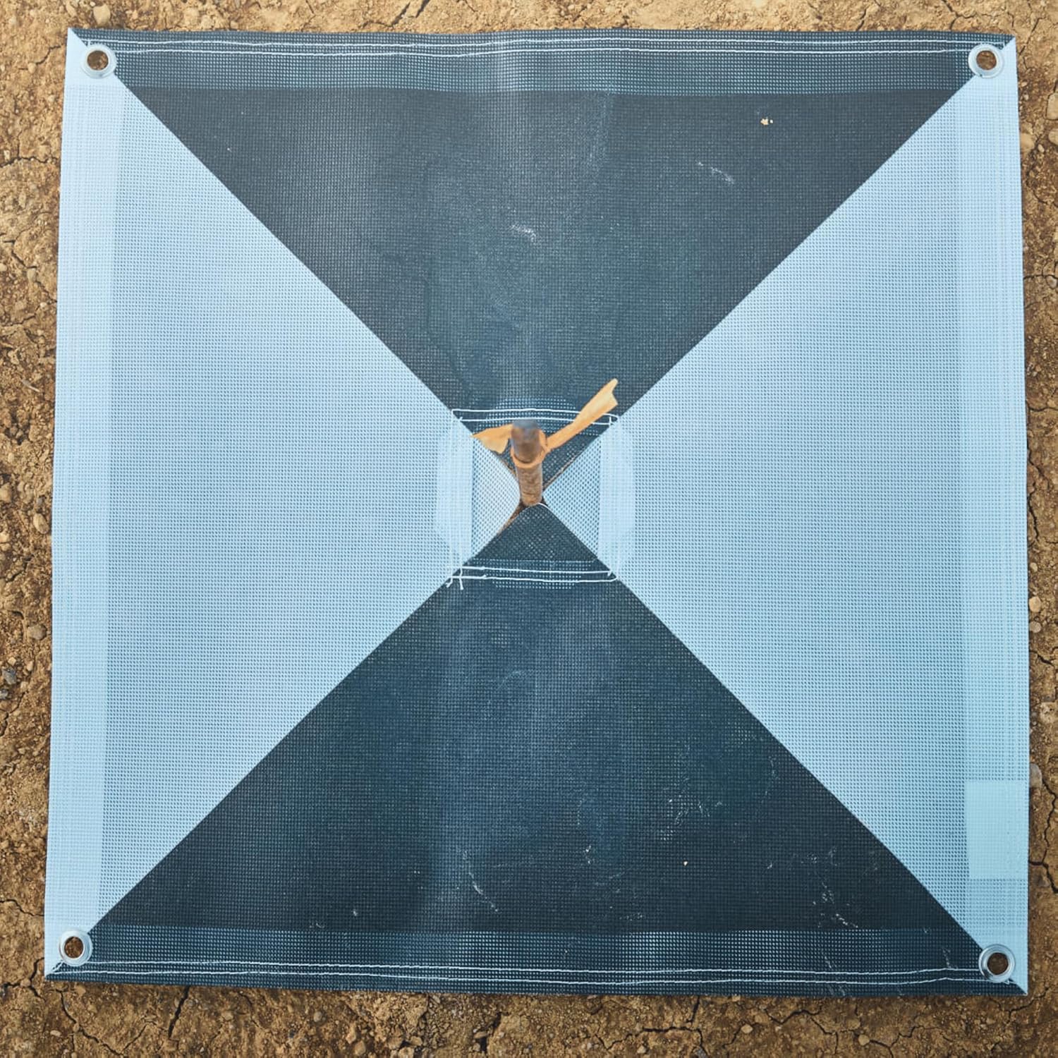
Sky High Bull’s-Eye made precision survey- ing easy by the center eyelet design, with reduced possibility of damaging the drone GCP
The Ideal dimension of 24″ x 24″ makes aerial targets easy to scale during map reconstruction, and its lightweight, durable, material makes it easy to carry and store. To ensure that the drone ground control points remain at the intended coordinates, there is an eyelet at each of the aerial targets’ four corners, allowing the drone targets to be easily anchored to the ground.
Key Features Center point for high-precision, repeatable measurements Durable with an estimated lifespan of 5+ years Anti-reflective coating for reduced glare Four (4) anchor points to secure to the ground as needed Multiple GCP options to best suit your workflow

These drone GCPs are specifically designed for aerial surveying and come with a center eyelet to accommodate your drone mapping workflow and easily identifiable from altitude

These lightweight GCPs are easy to deploy on any surface and can be folded & carried into a small carrying bag or backpack when reaching control points on foot

These ground points are made to withstand all weather conditions, allowing you to spend more time on your mapping and surveying without worrying about your GCPS

These aerial survey targets are made of a durable mesh material having an anti-reflective coating that reduces glare from the sun, resulting in better mapping


GCP Pattern Options
Square (Checkerboard) Pattern
The square GCP pattern (otherwise known as checkerboard pattern) is the most common aerial target pattern. As a result, this pattern is compatible with most au- to-detection software.
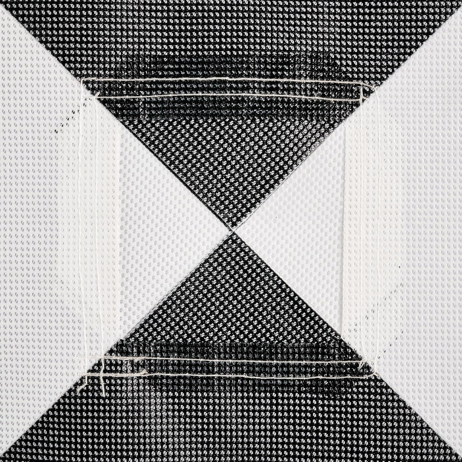
Iron Cross (Harlequin Cross) Pattern
This GCP pattern is another common pat- tern that has been shown to improve center point location in some research studies as the border between the two colors is longer than with the traditional square pattern, allowing for more precise counterpoint identification. Please check with your preferred software provider to ensure that this GCP pattern is supported prior to purchase.

GCP Color Options
Black and White GCPS
We offer all of our GCPs in the standard black and white color way. With high contrast, the black and white GCPs are widely recognized across the industry as the standard for aerial mapping.
Black and Grey GCPS
In some mapping operations, the combina- tion of black and grey GCPs have proven to be useful. The conceptual reason for using grey instead of white is that white is more easily overexposed which can reduce counterpoint accuracy. Grey is less likely to be overexposed but still provides enough contrast with black to allow for ceneter- point identification. The black and grey GCPs are particularly well-suited for map- ping operations that are performed in direct sunlight to reduce the risk of overex- posure.

GCP Size Options
24″x24″ GCPs
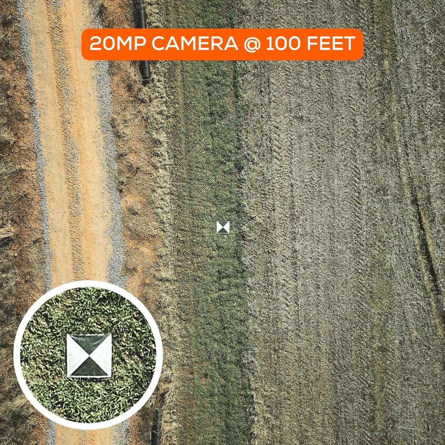
Our 24″ GCPs are ideal for UAV/drone mapping operations at altitudes up to the legal limit of 400 feet. We recommend using at least a 20 megapixel camera in order to accurately resolve the counter- point of the GCPs when mapping.
48″x48″ GCPS
Our 48″ GCPs increase the target size from 4 square feet to 16 square feet (a 300% increase) to enable mapping from high altitudes. Depending on the sensor quality and megapixel count of the camera, these GCPs can be used by manned aircraft mapping operations. We also recommend using these GCPs for drone operations that routinely map at or near 400 feet to increase the ease at which the GCPs can be identified.

Adhesive Backing
n/a n/a n/a n/a n/a n/a
Color
Black & White OR Black & Grey Black & White OR Black & Grey Black & White OR Black & Grey Black & White Black & White Black & White
Material
Polyester Polyester Polyester Polyester Polyester Polyester
Size
24″ x 24″ 24″ x 24″ 24″ x 24″ 24″ x 24″ 48″ x 48″ 48″ x 48″
Pattern
Iron Cross (Harlequin Cross) Pattern GCPS Square Pattern GCPs Square Pattern GCPs Square Pattern GCPs Square Pattern GCPs Iron Cross (Harlequin Cross) Pattern GCPS
Anchors
n/a 4 Corner Eyelets 4 Corner Eyelets 4 Corner Eyelets 4 Corner Eyelets 4 Corner Eyelets
Recommended Use Case
UAV/Drone Photogrammetry/Surveying UAV/Drone Photogrammetry/Surveying UAV/Drone Photogrammetry/Surveying UAV/Drone Photogrammetry/Surveying Manned Aircraft and/or UAV/Drone Photogrammetry/Surveying Manned Aircraft and/or UAV/Drone Photogrammetry/Surveying
Lifespan
5+ years 5+ years 5+ years 5+ years 5+ years 5+ years
Center Type
Center Passthrough Center Eyelet Center Eyelet Center Eyelet Center Eyelet Center Eyelet
Surface Finish
Anti-Reflective Matte Finish Anti-Reflective Matte Finish Anti-Reflective Matte Finish Anti-Reflective Matte Finish Anti-Reflective Matte Finish Anti-Reflective Matte Finish
Efficient Mapping: The novel center cutout design of the uav drone GCP markers enables seamless mapping with pre-established survey markers. Simply align your GPS with the center passthrough, ensuring accurate data capture and precise alignment with existing survey control points. Streamline your workflow and save valuable time in the field.
Secure Ground Placement: Each aerial target ground marker is equipped with four corner anchor points, allowing for easy and reliable affixation to the ground. Ensure stability and consistency during data capture by securely fastening the drone GCP targets in place. This feature guarantees precise and consistent results, even in challenging terrain or windy conditions.
Clearly Visibile from High Altitudes: Our GCPs feature clear and distinct patterns, facilitating easy identification of individual targets. Quickly locate and reference specific points during your mapping missions, ensuring efficient data collection and analysis. Stay organized and ensure accuracy with our highly visibile GCPs.
Long-Lasting Durability: Crafted with durability in mind, the are built to withstand the demands of repeated use in various environments. Constructed from high-quality materials, this drone target center point offers exceptional longevity, providing reliable performance throughout your mapping and surveying projects. Invest in a tool that will serve you for years to come.
Portable and Lightweight Design: The foldable and lightweight nature of the Bull’s-Eye GCPs makes them highly portable and easy to transport. Conveniently pack and carry these GCPs to different job sites without hassle. Their compact form factor allows for efficient storage, enabling you to bring the necessary equipment wherever your mapping and surveying projects take you.
User Reviews
Only logged in customers who have purchased this product may leave a review.
Related Products


$59.99

There are no reviews yet.